
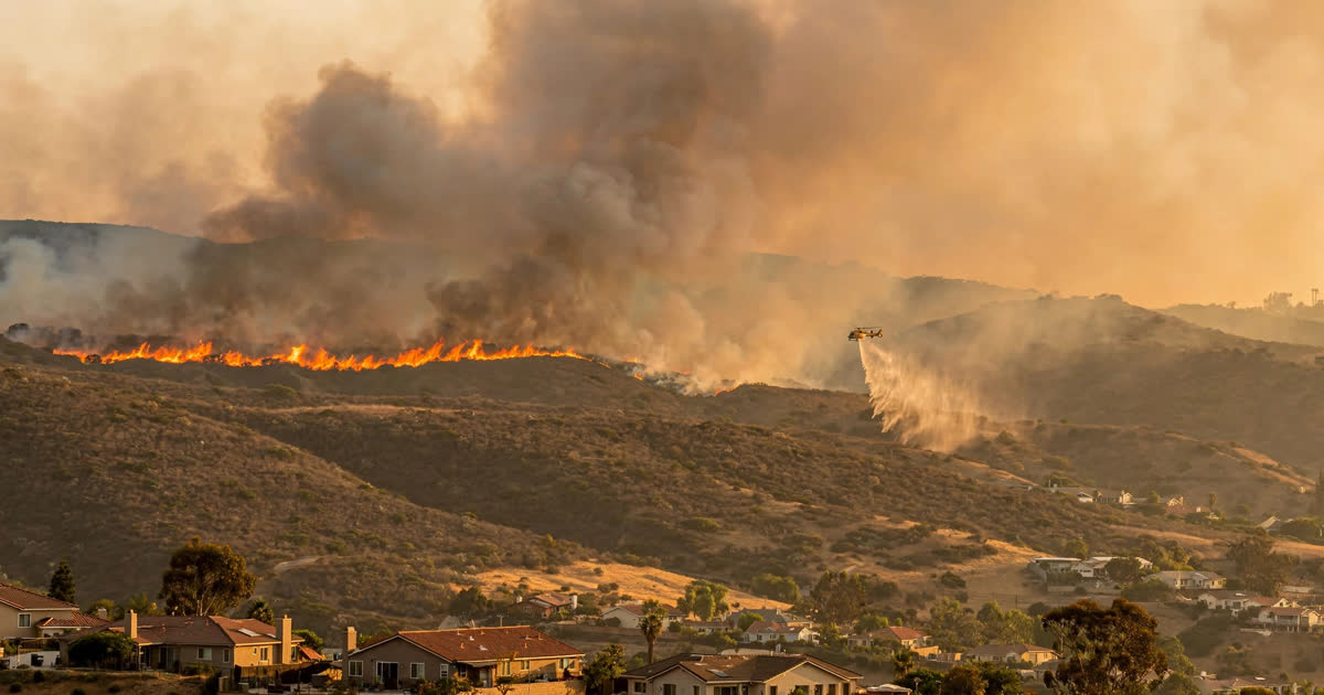
On Friday afternoon, 16 October 2026, a fast-moving brush fire erupted in the coastal hills of Orange County, California, and within hours was burning through neighbourhoods that had rarely faced wildfire danger before. The blaze, named the Norte Fire for the street near where it started, grew to at least 465 acres, destroyed or damaged at least six homes, and forced evacuation orders covering roughly 4,600 homes and about 16,000 residents in San Clemente and San Juan Capistrano. The fire is trending per news coverage across the United States, and it became the most dramatic of several wildfires that ignited across Southern California as fierce Santa Ana winds battered the region.
How the Norte Fire grew so fast
The fire was first reported shortly before noon near the intersection of Portico Del Norte and Eminencia Del Norte in San Clemente, a coastal city roughly midway between Los Angeles and San Diego. The California Department of Forestry and Fire Protection, known as CAL FIRE, logged the start at 12:01 p.m. local time; the Orange County Fire Authority said the first reports came in just after 11:30 a.m. Within about 30 minutes, the fire had grown from about 10 acres to roughly 50 acres. By the early afternoon it had passed 250 acres, and by late afternoon officials put it at 465 acres. A later CAL FIRE estimate put the burned area at around 570 acres, a reminder that early figures in a fast-moving fire are often revised as mapping improves.
Fire officials said topography and weather did much of the work. The blaze started in dry brush on steep hillsides above suburban streets, and strong winds pushed it rapidly from San Clemente into neighbouring San Juan Capistrano. “Topography and weather conditions allowed the fire to grow rapidly,” Orange County Fire Authority Division 3 Chief Mark Backoff said in a video update posted on Friday afternoon. By Friday evening, officials said the fire was still 0% contained, but that crews had knocked down a majority of the flames. “A majority of the fire has been knocked down. However, we still have some homes that have been impacted here, and as you can see, the wind is still blowing pretty strong up here,” fire authority spokesperson Steve Concialdi said. Orange County Fire Authority Chief TJ McGovern said the immediate objective was “keeping the fire within its current footprint.”
Evacuations across two cities
As the flames advanced on subdivisions, authorities issued mandatory evacuation orders for five zones: San Juan Capistrano zones SJC04, SJC05 and SJC10, and San Clemente zones SCL12 and SCL13. Law enforcement officers went door to door in threatened streets, urging residents to leave immediately. According to the Orange County Fire Authority, the orders covered roughly 4,600 homes and about 16,000 people, although some reports put the number of homes under evacuation orders closer to 6,000 as warnings expanded through the afternoon.
Emergency shelters opened in both cities: the San Juan Capistrano Community Center at 25925 Camino del Avion, and the San Clemente Community Center at 100 Calle Seville. The Capistrano Unified School District dismissed students early from about nine campuses in the affected area and cancelled after-school activities, including high school football games. Traffic jammed on Interstate 5 near the fire as residents tried to leave and onlookers slowed to watch.
Among those forced to flee was U.S. Representative Mike Levin, whose home is in San Juan Capistrano. He attended a local news briefing to thank emergency crews, saying his family was grateful for the firefighters who had worked through the day. For many residents, the evacuation was a first. “I’ve lived here since 1995, and this is the first time we’ve really ever had a fire in this area,” San Clemente resident Robert Morris told KCBS, calling the sudden threat to homes “a wake-up call.”
Homes lost and firefighters hurt
At least six homes were damaged or destroyed, most of them in San Juan Capistrano. County fire officials said four homes off Via La Mirada had been “impacted” in an update issued just before 2:30 p.m. on Friday, and aerial footage showed flames punching through the roofs of large houses while neighbouring properties faced direct threats from the advancing fire. One homeowner, Mark McNabb, said his San Juan Capistrano house of ten years was lost despite precautions: “We just installed a fireproof roof and boxed in the eaves.” Officials cautioned that the final tally of damaged and destroyed homes would not be known until damage assessment teams could safely enter the burned area.
Two firefighters suffered significant injuries and were reported stable in area hospitals, fire officials said. Another firefighter was treated for heat exhaustion as crews worked in mid-90s Fahrenheit heat. No civilian injuries had been reported as of Friday evening, though officials stressed that the situation remained dangerous and that residents should not re-enter evacuated areas.
The firefight on the ground and in the air
More than 500 firefighters attacked the Norte Fire from the ground and the air, backed by air tankers dropping retardant and helicopters making water drops on the flanks of the blaze. The steep, brush-covered terrain made direct attack difficult in places, and shifting winds repeatedly threatened to push the fire into new streets. Officials repeatedly urged the public to stay clear of the area so that crews and aircraft could work without interference.
California secured federal help within hours. The governor’s office said the Federal Emergency Management Agency had approved a Fire Management Assistance Grant for the Norte Fire. The grant is provided on a cost-share basis and reimburses 75% of eligible firefighting costs, easing the financial burden on local and state agencies responding to a major blaze. It does not cover all costs, and it applies to suppression expenses rather than to rebuilding or private losses.
Why the Santa Ana winds make fires explode
The Norte Fire is a textbook example of what Santa Ana winds can do. These are strong, dry winds that blow from the interior deserts of the south-western United States toward the California coast, typically in autumn. As the air descends from higher elevations toward sea level, it compresses and warms, arriving at the coast hot and extremely dry. On Friday, coastal gusts reached roughly 35 to 55 mph, temperatures climbed into the mid-90s Fahrenheit, and humidity fell to very low levels — a combination that turns brush into fast-burning fuel and lets even a small ignition run for miles.
The timing matters too. Santa Ana season arrives just as Southern California’s vegetation is at its driest after a long, rainless summer. Forecasters said the strongest winds were expected through Friday, but the heat and low humidity feeding the fire were forecast to last through Saturday night, keeping the risk high even after the first winds eased. Wildfire seasons around the world have grown more destructive in recent years, from Indonesia’s peatland wildfires choking South-East Asia to repeated autumn blazes across the American West, and scientists note that warmer, drier conditions have lengthened California’s fire season and increased the number of days when fires can grow explosively.
A region on edge
The Norte Fire was not the only blaze burning in Southern California on Friday. The Bryson Fire in the Malibu hills of Los Angeles County had burned about 200 acres and was also 0% contained, while the Henderson Fire in San Diego County near Camp Pendleton had burned about 1,404 acres, also with 0% containment. The Henderson Fire closed Interstate 5 in both directions near Basilone Road, compounding the traffic chaos from the Norte Fire evacuations.
The National Weather Service kept Red Flag warnings and high wind warnings in place through Saturday, meaning rapid fire growth remained possible across the region. Utilities carried out precautionary public-safety power shutoffs to reduce the risk that wind-damaged electrical equipment could spark new fires, leaving tens of thousands of customers without electricity. Smoke from the fires degraded air quality across parts of the coast, and officials advised residents to stay indoors where possible and to keep windows closed. The same week brought other emergencies around the Pacific, including a typhoon warning for Guam as Tropical Storm Champi approached the Mariana Islands.
What happens next
Fire officials said their immediate priorities were containment, structure protection and damage assessment. Containment figures can move slowly at first: a fire can be largely knocked down, as officials said of the Norte Fire on Friday evening, and still be listed at low containment until crews have built secure lines around its full perimeter. Residents under evacuation orders were told to be patient and not to return until officials declare their zones safe, even if smoke appears to have cleared.
The cause of the Norte Fire remained under investigation as of Friday evening, and officials asked anyone with information or video of the fire’s early minutes to come forward. For residents, the official sources for updates are the Orange County Fire Authority, CAL FIRE and the Orange County Sheriff’s Department, which maintains the evacuation zone map. Those in the region can sign up for AlertOC, the county’s emergency notification system, for evacuation orders and warnings.
The Norte Fire is a reminder of how quickly a Southern California afternoon can turn dangerous when wind, heat and dry brush align. For the families who fled San Clemente and San Juan Capistrano on Friday, the coming days will bring the slow work of damage assessment, insurance claims and, for at least six households, the long task of rebuilding. For firefighters, the next 48 hours will decide whether the fire stays within its current footprint or finds new fuel in the next gust.
Sources: CNN; USA Today; Associated Press; Orange County Fire Authority; CAL FIRE; Office of the Governor of California; AFP. Figures are as reported on Friday evening, 16 October 2026, local time, and may be revised as officials complete damage assessments.