
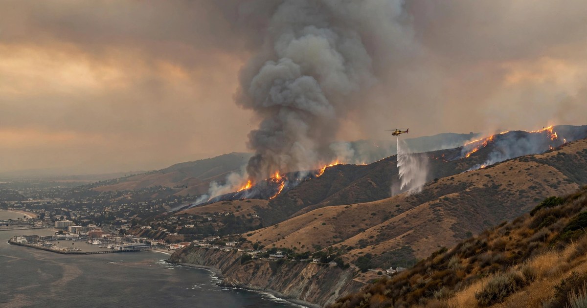
A fast-moving brush fire that erupted in the Santa Monica Mountains above Malibu on Thursday afternoon, October 15, 2026, forced evacuation orders, shut down roads, cut power to tens of thousands of homes, and closed the Getty Villa, as firefighters battled wind-driven flames through the night. The Bryson Fire, which ignited near Encinal Canyon Road and Mulholland Highway in western Malibu, had burned about 147 acres and was 17% contained by Friday morning local time, according to CAL FIRE and the Los Angeles County Fire Department. One firefighter suffered minor injuries. No homes had been reported damaged or destroyed as of Friday morning, though fire officials said more than 100 structures were threatened, and a Friday incident update put the wider number of threatened structures at more than 7,000. The fire is trending per news coverage across US outlets as Southern California faces another dangerous round of Santa Ana winds.
How the Bryson Fire grew so fast
The Bryson Fire was reported just before 5 p.m. on Thursday, October 15, near Encinal Canyon Road and Mulholland Highway, close to the Los Angeles County juvenile facility known as Camp Kilpatrick. In the dry brush of the Santa Monica Mountains, and with gusty winds pushing the flames, it exploded almost immediately. Fire officials said it grew from roughly half an acre to about five acres in its first 15 minutes, reached about 20 acres within half an hour, and ballooned to roughly 200 acres by Thursday night.
Incident commanders issued a second alarm to summon additional crews, and water- and retardant-dropping helicopters and fixed-wing aircraft were dispatched to the scene, including aircraft able to fly at night. Despite that aggressive air attack, the fire was still listed at 0% containment late Thursday as wind-driven spot fires jumped ahead of the main blaze through largely inaccessible terrain. Overnight, firefighters and the air attack pushed containment to 5%, and by Friday morning, after crews mapped the fire more precisely, CAL FIRE listed it at about 147 acres and 17% contained. The smaller acreage figure reflects more accurate mapping, not a shrinking fire: the perimeter was better measured once daylight and aircraft mapping gave crews a clearer picture.
Los Angeles County Fire Department Chief Anthony Marrone said at a Friday morning press conference that the fire was burning rapidly in medium to heavy fuels. The response is being run under a unified command of the Los Angeles County Fire Department, the Los Angeles County Sheriff’s Department, and CAL FIRE’s San Bernardino Unit, with several hundred personnel assigned, including more than 300 firefighters. Firefighters were focused on structure protection and building containment lines ahead of another windy day.
Evacuation orders, warnings and road closures
Authorities issued a mandatory Level 3 “Go” evacuation order for zones KAN-U017 and SYC-U016-A, covering the Encinal Canyon area near Trancas Canyon, where residents were told to leave immediately. A wide ring of surrounding zones was placed under Level 2 “Set” evacuation warnings, meaning residents should be ready to leave at a moment’s notice. Those warning zones included CRN-U019, LBO-U018, LEO-U015, MAL-C113, MAL-C114, MCR-U021-A, MLK-U020, SYC-U016-B, SYC-U016-C, SYC-U016-D, VST-U046 and WLV-C201, stretching toward the Pacific Coast Highway, Zuma Beach, Leo Carrillo State Park, Paramount Ranch and the Kaslow Natural Preserve. Officials split two large zones to give more precise orders: MCR-U021 was divided, with MCR-U021-A under a warning and MCR-U021-B clear, while SYC-U016 was split into four parts, with only SYC-U016-A upgraded to a full evacuation order.
The Los Angeles County Probation Department evacuated 38 young people from Campus Vernon Kilpatrick and moved them to Barry J. Nidorf Juvenile Hall in Sylmar. The American Red Cross opened an emergency shelter at Agoura High School at 28545 W. Driver Avenue in Agoura Hills. Pepperdine University, about eight miles from the fire, said the blaze did not currently pose a threat to its Malibu campus. The Getty Villa museum was closed on Friday out of an abundance of caution, and Los Angeles County officials urged residents in affected areas to monitor official alerts and stay out of the fire zone so emergency crews could work.
Road closures added to the disruption. Authorities closed Decker Road at Encinal Canyon Road, Kanan Road at Mulholland Highway, and Mulholland Highway at Westlake Boulevard. Topanga Canyon Boulevard between Mulholland Highway and Pacific Coast Highway was restricted to resident-only access until the red flag warnings expire. The latest evacuation information is published on the Genasys Protect evacuation map used by Los Angeles County.
Santa Ana winds: why this fire is so dangerous
The Bryson Fire erupted during a classic Southern California autumn setup: Santa Ana winds. These are dry, gusty winds that form when high pressure builds over the interior deserts and Great Basin and air is pushed downhill through mountain passes and canyons toward the coast. As the air descends it warms and dries out, humidity plunges, and vegetation that is already parched after the long dry season becomes ready to burn. The result is what meteorologists call critical fire weather: low humidity, strong and erratic gusts, and fast-moving fires that can outrun initial attack crews.
The National Weather Service in Los Angeles placed the Malibu coast under a red flag warning through the evening of Saturday, October 17, with critical fire weather expected across much of southwest California through Saturday. Forecasters warned of wind gusts of 40 to 65 miles per hour as the Santa Ana event peaked, and gusts of up to 60 mph were forecast for Friday alone. An L.A. County Fire Department spokesman told NBC Los Angeles that the wind “makes it hard, and it makes the fire move faster through the dry fuel.”
The terrain makes the job harder still. The Santa Monica Mountains are steep, brush-covered and laced with canyons that funnel wind and funnel fire. The dominant vegetation, chaparral, is a dense, oily shrubland that is adapted to burn: it ignites readily, burns hot, and regrows after fire. Where homes sit close to that brush — the wildland-urban interface that defines much of Malibu — firefighters must defend structures at the same time as they try to hold a fast-moving perimeter. That is why a fire of under 150 acres can still threaten thousands of structures and force wide evacuations: it is not only the size of the fire, but how fast the wind can push it toward homes.
California’s wildfire risk has also been rising as the climate warms, with longer dry seasons and more extreme heat drying out vegetation earlier in the year. The Bryson Fire is a reminder that Southern California’s most dangerous fire weather often arrives in autumn, when the Santa Ana season overlaps with fully cured summer vegetation. Similar wind-driven fires have repeatedly threatened the same canyons and coastal communities, which is why officials treat every red flag day as a day to be ready to evacuate.
Power shutoffs: why tens of thousands lost electricity
As the fire burned, Southern California Edison cut power to large parts of the region under its Public Safety Power Shutoff programme, a preventive measure designed to stop wind-damaged power lines from sparking new fires. More than 60,000 Edison customers in Los Angeles and Ventura counties were without power late Thursday night, according to the Los Angeles Times. By Friday morning, nearly 35,000 Edison customers in Los Angeles County had power shut off because of heightened wildfire risk, and the utility was considering shutoffs for tens of thousands more as the winds continued.
Preventive shutoffs are deliberately disruptive, and they are controversial with residents who rely on power for medical equipment, work and communication. Utilities say the trade-off is necessary: during the strongest Santa Ana gusts, a single downed line or a branch striking a wire can ignite a fire that moves faster than crews can chase it. During a red flag warning, shutting off circuits in the highest-risk areas removes that ignition source entirely. Residents can check Edison’s outage map for the status of their circuit, and officials advise keeping phones charged, keeping a battery-powered radio handy, and never running a generator indoors.
What happens next
The immediate question is whether crews can hold and widen containment before the strongest winds arrive. Fire officials said Friday that they would keep up the air attack and focus on structure protection, hoping to build containment through the day. But with gusts forecast to reach 40 to 65 mph through Saturday, even a well-fought fire can throw embers far ahead of its edge and start new spot fires, which is why evacuation warnings cover such a wide area.
The cause of the Bryson Fire remains under investigation, and officials had not determined what sparked the blaze as of Friday morning. Investigators typically examine the ignition point, look for evidence of power-line involvement, lightning, equipment use or human activity, and compare the timeline with reports from the first crews on scene. Until that investigation is complete, the cause should be treated as unknown.
For residents, the key steps are familiar but urgent: know your evacuation zone, sign up for county emergency alerts, keep a go-bag ready with documents, medication, water and pet supplies, and leave immediately if an evacuation order is issued. Those who need extra time to evacuate, including people with pets or livestock, are urged to leave early rather than wait for an order. The fire is still active and conditions can change quickly, so the safest source of information is the official channel: CAL FIRE incident updates, the Los Angeles County Fire Department, the Sheriff’s Department, and the Genasys Protect evacuation map. This article will be updated as the situation develops, and the same wind-driven conditions behind this fire are also fuelling fire risk across the wider region, from peatland fires in Indonesia to storm-driven emergencies like Hurricane Trudy off Mexico’s Pacific coast and the magnitude 7 earthquake that struck Russia’s Kamchatka Peninsula.
Frequently asked questions
How big is the Bryson Fire and how contained is it?
As of Friday morning, October 16, CAL FIRE listed the Bryson Fire at about 147 acres with 17% containment. The fire had been estimated at roughly 200 acres on Thursday night with 0% containment, but the lower Friday figure reflects more accurate mapping by crews and aircraft, not a smaller fire. Containment means the share of the fire’s perimeter where crews have built a line they expect the fire will not cross.
Which areas are under evacuation orders?
Mandatory evacuation orders were in place for zones KAN-U017 and SYC-U016-A in the Encinal Canyon area near Trancas Canyon. More than ten surrounding zones, including areas near Zuma Beach, Leo Carrillo State Park and the Pacific Coast Highway, were under evacuation warnings. Residents should check the Genasys Protect map for their exact zone, because orders and warnings can change quickly.
Was anyone hurt, and were any homes destroyed?
One firefighter suffered minor injuries and was taken to a local hospital, according to the Los Angeles County Fire Department. As of Friday morning, Malibu officials said they were not aware of any homes damaged or destroyed, though more than 100 structures were threatened and a Friday incident update put the wider threatened-structure count above 7,000.
What caused the Bryson Fire?
The cause is under investigation and had not been determined as of Friday morning. The fire broke out near Encinal Canyon Road and Mulholland Highway during a Santa Ana wind event, but investigators have not yet said what ignited it. Officials ask the public to avoid speculation while the investigation is under way.
What are Santa Ana winds, and how long will the danger last?
Santa Ana winds are dry, gusty offshore winds that blow from the interior deserts toward the Southern California coast, warming and drying as they descend through mountain passes. They drop humidity and drive fires fast through dry brush. The National Weather Service had the Malibu coast under a red flag warning through the evening of Saturday, October 17, with gusts of 40 to 65 mph forecast, so the danger was expected to continue through the weekend. The same Santa Ana winds also drove the Norte Fire in Orange County, where homes burned and thousands were evacuated.