
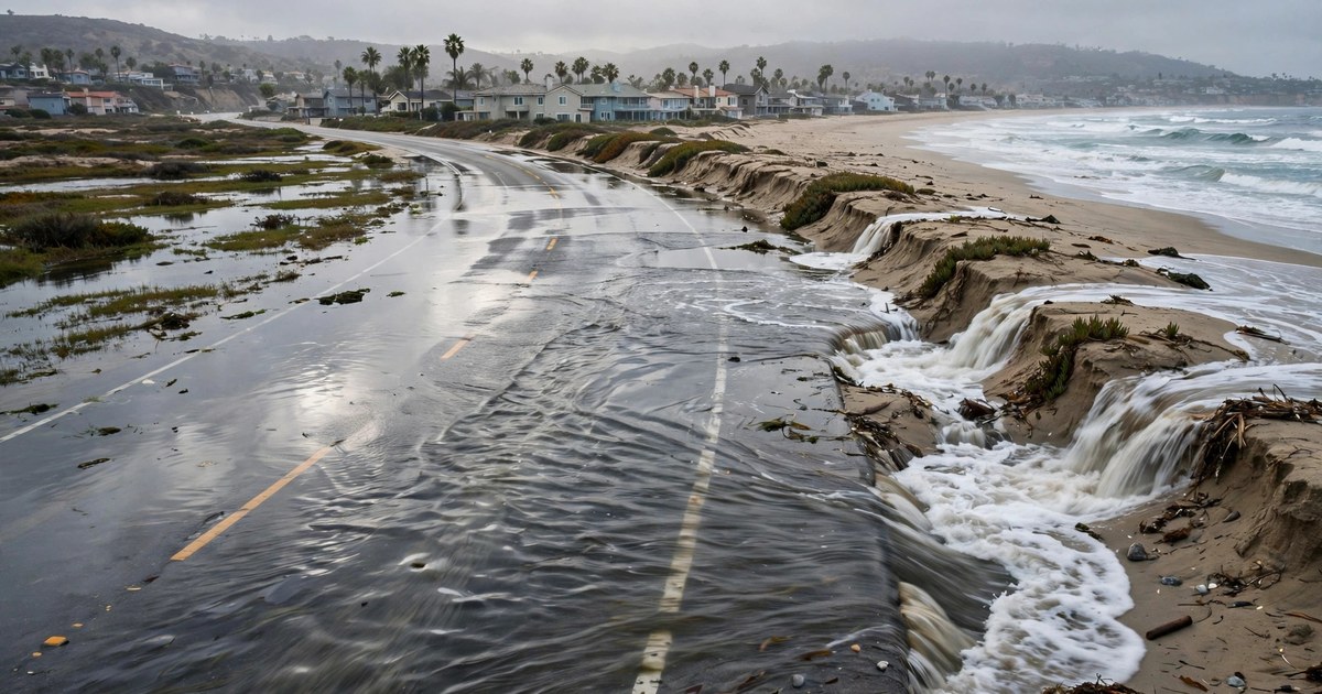
California king tides turned an ordinary autumn morning into a flood emergency along the Southern California coast on Tuesday, 27 October 2026. Seawater spilled across Pacific Coast Highway, known as PCH, flooded streets in waterfront neighbourhoods, and forced road closures in Orange County while forecasters warned that unusually high morning tides could bring more flooding through Thursday. The flooding, trending per news coverage across the United States on 27 October 2026, was not caused by a storm making landfall. It was the sea itself arriving higher than the charts predicted, on top of an already high astronomical tide.
For residents of Huntington Beach, Newport Beach, Seal Beach and Long Beach, the week had already been building toward this point. A coastal flood warning was in effect for the Orange County and San Diego County coasts, and a broader coastal flood advisory covered much of the California coast. By Tuesday morning, the water was no longer a forecast. People were photographed walking dogs through flooded streets, paddling through standing water on the closed highway, and watching crews build sand berms while pumps worked to clear residential roads. The message from forecasters and city officials was consistent: expect the highest water in the morning, expect it again at night, and do not assume that a dry road at midday means the danger has passed.
What happened on Pacific Coast Highway on 27 October 2026?
In Orange County, flooding forced the closure of both directions of PCH between Warner Avenue and Seal Beach Boulevard on Tuesday morning, according to Caltrans, as reported by the New York Post. Northbound lanes were also closed between Seapoint Street and Warner Avenue. As water continued to spill onto the roadway even after the tide began to recede, PCH was ultimately shut down in both directions between Seal Beach and Huntington Beach. A planned closure window from 8 a.m. to noon had been announced in advance, and by 10 a.m. on Tuesday, partial closures were also in effect along PCH between Warner Avenue and Anderson Street in the Sunset Beach area, according to FOX 11 Los Angeles. Officials warned motorists to expect full closures along that stretch during periods of high tide.
The flooding was not limited to the highway. The waterway beneath the Newport Boulevard Bridge was closed from 8:30 a.m. to 10:30 a.m. on Tuesday to prevent boat wakes from sending more water into nearby properties during the morning high tide, and it was scheduled to close again on Wednesday from 9 a.m. to 11 a.m. Boaters throughout Newport Harbor were urged to slow down and exercise caution near low-lying waterfront areas. Newport Beach officials also suspended parking enforcement through Wednesday evening to give residents time to move vehicles out of flood-prone areas, a practical step that underlined how much of the risk was about cars and ground-floor property as much as about the beach itself.
California king tides: where the flooding hit hardest
The Sunset Beach community in Huntington Beach became one of the most visible images of the event, with floodwater covering the closed highway and spilling into low-lying streets. In Huntington Harbour, a community where many homes and walkways sit directly along channels connected to the ocean, rising tides also raised water levels throughout the harbour, pushing water over the edges of low-lying waterfront areas and onto streets and sidewalks. FOX 11 Los Angeles reported video of a man kayaking down a flooded roadway in the area, and city crews worked to pump water off residential streets, including along Bayview Drive. Huntington Harbour is particularly exposed in these conditions because the harbour channels transmit the ocean tide directly into the neighbourhood, so a high tide offshore becomes a high water level at front doors.
Newport Beach braced for the same water with pumps activated and sand berms built to protect vulnerable neighbourhoods, particularly along the Balboa Peninsula, where footage showed seawater spilling across streets and drivers navigating standing water as businesses tried to protect their doors. In Long Beach, residents watched workers use an excavator to build a sand berm in preparation for the high tides, and a resident was photographed walking a dog through a partly flooded parking lot. San Diego and Santa Monica also saw more than 2.5 feet of coastal flooding on Monday, according to Fox Weather, showing that the event stretched well beyond a single stretch of Orange County beach.
Further south, the longer-running damage to the shoreline made the high water harder to absorb. Laguna Beach had previously declared a local emergency after hurricane-generated surf stripped beaches of protective sand and damaged seawalls, and six homes along Ocean Way and Lagunita Drive were yellow-tagged, according to The Weather Channel. Exceptionally high tides arriving on top of that eroded, weakened shoreline compounded the damage, which is why the National Weather Service warning cautioned that low-lying property, including homes, businesses and some critical infrastructure, would be inundated. The pattern across the coast was therefore not one single flood, but the same high water meeting different local weaknesses: a highway at Sunset Beach, harbour channels at Huntington Harbour, an eroded beach at Laguna Beach, and low-lying streets in Newport Beach and Long Beach.
Why are California king tides so high in 2026?
No single factor is driving the flooding. Meteorologists and ocean scientists quoted in reporting on 26 and 27 October described a convergence of several conditions at once, and each one added inches that mattered when the water reached a seawall, a road or a garage. Understanding the California king tides of October 2026 means keeping those factors separate, because only one of them is the tide itself.
First, the astronomical tide was already exceptionally high. A full moon on 26 October converged with the seasonal pattern that produces king tides, the highest high tides of the year, when the gravitational alignment of the Sun, Moon and Earth pulls ocean water higher than usual. Reporting drawn from the Los Angeles Times also pointed to a rarer alignment: the 18.6-year lunar node tidal cycle and the 4.4-year lunar perigee tidal cycle are peaking at the same time, a combination described as occurring roughly once every two decades. In other words, the Moon was in a position to make an already high tide higher still.
Second, the ocean itself was higher than the astronomical tide alone would suggest. An El Nino-associated Kelvin wave, an enormous pulse of warm water travelling across the Pacific and up the California coastline, has temporarily raised sea levels, and the National Oceanic and Atmospheric Administration says Kelvin waves can add six to 12 inches to background water levels. At the same time, a marine heatwave, described in Los Angeles Times reporting as separate from El Nino, has kept near-shore waters abnormally warm for months. Warm water expands, so hotter ocean water takes up more space and raises coastal sea levels. The National Weather Service said actual tides in Southern California were running 1.25 to 1.75 feet above what the positions of the Earth, Sun and Moon alone would predict, and Newport Beach officials reported water running 15 to 22 inches above predicted tides.
The temperature figures make that abstract point concrete. At Scripps Pier in La Jolla, surface water reached a high for the year of about 77 degrees Fahrenheit, when the average maximum is around 70 degrees, and on the Thursday before the peak tides it was about 73 degrees, well above the average of 66 degrees for that time of year. Reinhard Flick, a researcher at the Scripps Institution of Oceanography at the University of California, San Diego, was quoted as saying the sustained elevation was, as far as he knew, unprecedented, especially for its length of time, with water levels at least half a foot above prediction for months. Daniel Swain, a climate scientist at the University of California Agriculture and Natural Resources, warned that it was likely to get worse before it got better. Human-caused global warming is also part of the background: sea levels have risen about one foot over the past 125 years on the California coastline, according to the Los Angeles Times, so every king tide now starts from a higher baseline than the same tide a century ago.
What the tide records actually show
The records reported on 26 and 27 October show why forecasters treated this week differently from a routine high tide. A tide gauge in San Pedro reached 8.02 feet on Monday, breaking the previous record of 7.93 feet set on 10 January 2005, according to the National Weather Service, with records at that gauge dating back to November 1923. USA Today also reported that a new high tide record was set at Los Angeles Harbor on 26 October. Those are not forecasts or estimates. They are measured water levels that exceeded every previous measurement at gauges with a century of history behind them.
In Newport Beach, the city published adjusted forecasts that accounted for the unusually warm ocean water, putting the highest tides at 8.3 feet on Monday morning, 8.5 feet on Tuesday and 8.4 feet on Wednesday, figures about 1.8 feet higher than predictions that did not account for the warmer water. The city declared a local emergency, activated its emergency operations centre, and worked on reinforcing protective sand berms while preparing pumps and tide valves in flood-prone areas. In La Jolla, waters reached 7.66 feet over the weekend, approaching the all-time record of 7.81 feet set in November 2015. The same high-water pattern was not confined to California: USA Today reported record-breaking high tides along both the Southern California and south-eastern United States coasts in the same week, with new records set on four of the last five days in Miami, which is why the California event should be read alongside record king tides flooding Florida in 2026 rather than as an isolated local flood.
Two cautions matter when reading those numbers. First, different gauges measure different places, so a record at San Pedro, a forecast peak at Newport Beach and a near-record at La Jolla are not three measurements of the same water. They are separate local readings that together show a coastline-wide elevation. Second, a forecast peak is not the same as an observed peak. Newport Beach's 8.5-foot figure for Tuesday was the adjusted forecast for the morning high tide, and the observed flooding on Tuesday morning confirmed that water reached streets, roads and properties even where the exact peak reading varied by location. The reliable conclusion is the one forecasters themselves drew: water levels were running well above astronomical predictions across Southern California, and several local records were broken or approached in the process.
How long will the California king tides flooding last?
The coastal flood warning for the Orange County and San Diego County coasts was in effect from 5 a.m. on Sunday until 1 p.m. on Thursday, with a broader coastal flood advisory along the California coast from 25 to 29 October, according to the National Weather Service reporting summarised by Zark News. A coastal flood warning also remained in effect for the Orange County coastline through 1 p.m. on Thursday, while a coastal flood advisory covered the Los Angeles County coastline through the same time. Forecasters warned that tides could remain near record levels through Wednesday, with the highest water expected from Monday through Wednesday and high tides typically occurring between 9 and 10 a.m. and between 10 and 11 p.m. each day. Rain was also forecast by the weekend, according to USA Today, which would add runoff to a coast already dealing with seawater at street level.
That Thursday end point is not the end of the king tide story. Similar high-water setups are expected around the new moon in about two weeks, and forecasters and scientists quoted in the reporting expect even higher king tides around Thanksgiving, Christmas and Martin Luther King Jr. Day. The warning for this week should therefore be read as the first chapter of a season, not a single event. If strong winter storms coincide with those later king tides, coastal flooding could be considerably worse, because storm surf on top of an already elevated sea level reaches further inland and does more damage to beaches, seawalls and low-lying property than either factor alone.
What officials did, and what to do near the coast
Cities along the coast responded with the tools available for a slow, predictable flood: closures, berms, pumps and sandbags. Newport Beach declared a local emergency and approved a sand replenishment project to build a sand berm along beaches eroded by swells from large Pacific hurricanes earlier in the year. Residents picked up thousands of sandbags ahead of the peak tides, according to local reporting, while coastal crews reinforced beaches and flood-prone areas. Caltrans and city crews closed and managed PCH in planned windows so that drivers were not caught on a flooding road at the morning peak, and the Newport Boulevard Bridge waterway closures were timed to the same high tides. The pattern of the response matters for residents: the danger is predictable by the clock, so the closures, the bridge restrictions and the parking suspension were all built around the morning high tide.
For anyone living in or visiting a low-lying coastal area during a king tide week, the official advice in the reporting was straightforward. Move vehicles to higher ground before the morning high tide, protect flood-prone property, and take the necessary actions officials recommend for the specific neighbourhood, because flood depths vary street by street. Never drive through floodwater: water covering a road can hide damage, debris and a sudden drop, and a vehicle can be carried away in surprisingly shallow, fast-moving water. The standard safety advice repeated in flood coverage is to turn around rather than drive through standing water, and to follow closure signs and instructions from local officials rather than relying on a road looking passable at first glance. Residents were also urged to check with their city or public works department for sandbag distribution and local orders, since the exact streets affected differ between Newport Beach, Huntington Beach, Seal Beach, Long Beach and San Diego.
Why one week of high water matters for the whole winter
The October 2026 California king tides matter beyond the photographs of a flooded highway because they show how a coastline already changed by erosion, warm water and a higher sea level responds to a predictable astronomical event. The same tide that would have stopped at a seawall a generation ago now spills into streets, garages and homes, in the words of Newport Beach City Manager Seimone Jurjis, who warned that a foot and a half of extra water can determine whether water stays behind a seawall or pours into streets, garages and homes. That is the practical meaning of the extra 1.25 to 1.75 feet measured this week: it is the difference between a high tide to watch and a high tide to clean up after.
The winter ahead will test that difference repeatedly. The causes and effects of climate change include the long-term sea-level rise that raises the baseline for every king tide, while the shorter-term drivers this week, El Nino, the Kelvin wave and the marine heatwave, may evolve through the winter even as the astronomical cycles remain in place. What is certain is the calendar: more king tide periods are coming around Thanksgiving, Christmas and Martin Luther King Jr. Day, and forecasters have already warned that a similar setup could return around the next new moon. For coastal cities, the work done this week, berms built, pumps prepared, tide valves checked and emergency operations activated, is a rehearsal for those dates. For residents, the lesson of 27 October is simpler: check the tide times, move the car, respect the closures, and treat a sunny morning with a very high tide as seriously as a storm warning, because this week the sea arrived without a storm at all.
Sources: National Weather Service coastal flood warnings and tide-gauge data as reported by the New York Post and USA Today; City of Newport Beach adjusted tide forecasts and emergency measures as reported in local coverage; NOAA guidance on Kelvin waves; Scripps Institution of Oceanography researchers and University of California climate scientists quoted in Los Angeles Times reporting; Reuters, Associated Press, FOX 11 Los Angeles and Fox Weather reporting on flooding in Huntington Beach, Newport Beach, Seal Beach, Long Beach and Laguna Beach. Figures in this article are as reported on 27 October 2026; follow the latest National Weather Service warning and city orders for live updates.