
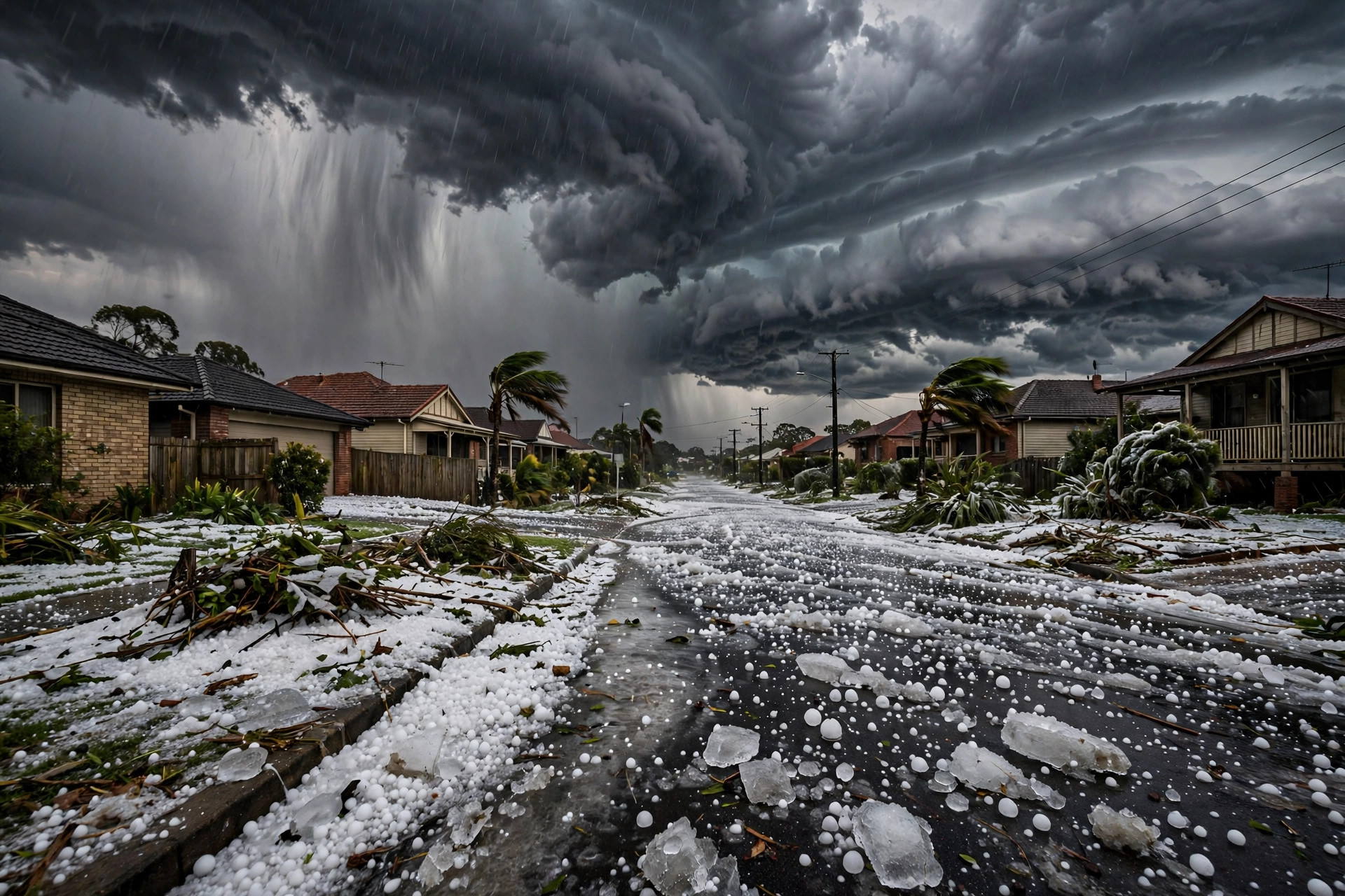
Queensland storms giant hail swept across south-east Queensland on Tuesday 27 October 2026, when severe thunderstorms and a dangerous supercell brought hailstones up to 7 centimetres across, power cuts, flooding and disruption at Brisbane Airport. Streets and gardens were covered in ice in some areas, vehicles were damaged, and more than 1,000 homes lost power in the Ipswich area. The Bureau of Meteorology issued severe thunderstorm warnings for a wide area including Logan, Ipswich, the Gold Coast, Brisbane City and the Scenic Rim. For residents, the afternoon was a sharp reminder of how quickly a Queensland storm can change from heavy rain to a damaging event, and how important it is to follow official warnings and stay out of floodwater.
Hail was reported between 2:30pm and 3:30pm at Yamanto, Flinders View, Ripley and Mudgeeraba, with stones measuring 3 to 7 centimetres. The largest reports, up to 7 centimetres, came from Mudgeeraba and White Rock. Stones of that size are far beyond the small pellets many people associate with hail. They can dent cars, break roof tiles and windows, strip leaves from trees and injure anyone caught outdoors without shelter. Images and reports of ice covering streets and gardens showed the scale of the fall in affected suburbs, where hail accumulated like snow and made roads slippery as well as damaged property. No casualty figures were reported in the sources used for this article, and this report does not invent any.
Queensland storms giant hail: what happened on 27 October
The storm system that produced the hail was described as a dangerous supercell. A supercell is a particular type of thunderstorm with a deep, rotating updraft. That rotation allows the storm to last longer and grow more intense than an ordinary thunderstorm. Strong updrafts lift raindrops high into cold parts of the atmosphere, where they freeze and grow as they collect more water. They may be carried up and down several times, growing larger with each cycle, before they finally become too heavy for the updraft to hold and fall to the ground as hail. The stronger and more sustained the updraft, the larger the hailstones that can form. Supercells can also produce damaging winds, intense rainfall and, in some cases, tornadoes, although the reports used here focus on hail, wind, lightning and flooding rather than on a tornado.
In Australian usage, the Bureau of Meteorology describes hail of 5 centimetres or more as giant hail, while hail of 2 centimetres or more is generally treated as severe. The distinction matters because it helps forecasters and emergency services communicate risk quickly. A forecast of giant hail warns people that stones may be large enough to cause serious damage to cars and buildings and to injure people outdoors. The 7-centimetre stones reported at Mudgeeraba and White Rock therefore exceeded the giant hail threshold by a clear margin. The 3 to 4-centimetre stones reported elsewhere were also well into the severe range. Size is usually measured by diameter, and even a difference of one or two centimetres can mean a much heavier stone, because volume and weight grow quickly as diameter increases.
Warnings covered a broad part of south-east Queensland. The Bureau of Meteorology warned of severe thunderstorms for Logan, Ipswich, the Gold Coast, Brisbane City and the Scenic Rim, among other areas. Warnings of this kind are issued when thunderstorms are expected to produce damaging winds, large hail, heavy rainfall or flash flooding. They are not a guarantee that every suburb in the warned area will be hit, but they are a signal to prepare: move cars under cover where possible, secure loose outdoor items, stay indoors during the storm, and avoid travel unless necessary. In this case, the warnings proved accurate for the suburbs that recorded large hail, and the timing of the hail reports in the mid-afternoon matched the passage of the most intense storms.
How supercells produce giant hail
Supercells form when warm, moist air near the ground meets cooler, drier air above, with wind changing speed or direction with height. That combination creates instability and rotation. The rotating updraft, sometimes called a mesocyclone, can sustain itself for hours and travel long distances. Inside the storm, water droplets are lifted into freezing air, form ice, and grow as supercooled water freezes onto them. Hailstones often show layers when cut open, reflecting the trips they made through different parts of the cloud. When they fall, they may be accompanied by heavy rain that reduces visibility and makes driving dangerous, and by lightning that adds a further risk to anyone outdoors.
Storms of this kind are a known feature of the Queensland storm season, which typically runs through the warmer months when heat and moisture are plentiful. Not every thunderstorm becomes a supercell, and not every supercell produces giant hail, which is why forecasting focuses on the specific ingredients present on a given day: moisture, instability, wind shear and a trigger to lift air, such as a trough or a change in wind. On 27 October, those ingredients came together over south-east Queensland in a way that produced a dangerous and damaging storm. Similar storm systems elsewhere in Australia and overseas can produce comparable hazards, and comparisons with other severe weather events, such as the Cyclone Arnab landfall with 150 kmph winds near Yanam, underline how wind, rain and storm surge or flooding can combine to disrupt communities in different ways.
Queensland storms giant hail: airport, power and flooding impacts
One of the most visible impacts was at Brisbane Airport. A lightning strike damaged the surface of the airport's western runway, forcing a temporary closure while repairs were carried out. The eastern runway reopened after a safety inspection, but flights were delayed as operations were adjusted and the damaged surface was assessed and repaired. Runway surfaces must meet strict safety standards, because aircraft land and take off at high speed and any damage to the surface can affect braking and control. A lightning strike can scorch, crack or displace pavement, and engineers must inspect the full affected area before the runway can return to use. For passengers, the result was delays rather than a prolonged shutdown, but even a temporary closure at a busy airport can ripple through schedules for the rest of the day.
Power supply was also affected. More than 1,000 homes lost power in the Ipswich area as storms passed through. Power cuts during storms can be caused by lightning strikes, wind bringing down lines or branches onto lines, or safety shutdowns to protect equipment and crews. Losing power affects lighting, refrigeration, communications and, for some households, medical equipment or water pumps. Energy crews typically restore supply in stages, prioritising safety and the largest numbers of customers first, but repairs can take time when roads are blocked or conditions remain dangerous. Residents are advised to treat fallen power lines as live, to keep clear of them, and to report them to the relevant authority rather than approaching them.
Flooding added a third strand of disruption. Three people were stranded in floodwaters in the Darling Downs. Moderate flooding was reported on the Mary, Weir and Warrego rivers and on Warrill Creek, while major flooding of Warrill Creek inundated the Ipswich golf course. Roads were cut, including roads around RAAF Base Amberley. Floodwater can rise quickly, hide road damage or debris, and carry strong currents even when it looks shallow. Authorities consistently advise never to drive, walk or swim through floodwater. The Darling Downs strandings and the road closures illustrate why that advice is repeated so often: a road that looks passable can conceal a washed-out surface, and water depth can change in minutes as upstream flows arrive. Transport disruption from severe weather can also affect rail and road networks in other parts of the country, as seen in separate incidents such as the Spain train crash at Urda, Toledo, although the causes there were different and the events should not be confused.
Staying safe and what comes next in Queensland
Safety advice during severe thunderstorms is straightforward, but it depends on acting early. When a severe thunderstorm warning is issued, the safest place is indoors, away from windows. Cars should be moved under cover if that can be done safely before the storm arrives, and loose outdoor furniture and equipment should be secured. During the storm, people should avoid using electrical equipment connected to mains power where possible, stay away from trees and power lines outdoors, and avoid sheltering under isolated trees or metal structures. After the storm, care is still needed: fallen branches and power lines, damaged roofs, slippery roads covered in hail, and floodwater all pose risks. Checking on neighbours, especially older people or those living alone, and reporting damage to the relevant authorities helps recovery proceed more smoothly.
The outlook after 27 October pointed to further unsettled weather. Further showers and thunderstorms were possible later in the week across Queensland, meaning residents could not assume the danger had passed with one storm. Each new day's forecast and warnings should be checked, because storm ingredients can rebuild quickly in warm, moist conditions. People planning travel, outdoor work or events should allow extra time, check road and airport information, and have a plan for shelter if a storm develops. Farmers and property owners may also need to check for damage that is not immediately visible, such as roof damage that could leak in later rain, or hail damage to crops and vehicles that should be photographed and reported for insurance purposes.
Broader context for the wet second half of October in eastern Australia was attributed by the Climate Impact Company to a combination of factors: a negative Southern Annular Mode, a shift in the Madden-Julian Oscillation, and a marine heatwave off the south-east coast. Those are large-scale climate patterns that influence winds, moisture and sea temperatures. A negative Southern Annular Mode can shift westerly winds and storm tracks in ways that bring more moisture to parts of eastern Australia. The Madden-Julian Oscillation is a pattern of tropical rainfall that moves around the globe and can enhance storm activity as it passes near Australia. A marine heatwave means unusually warm sea surface temperatures, which can add moisture and energy to the air above the ocean. None of these factors alone causes a single hailstorm, and scientists are careful to distinguish between the conditions that favour storms in general and the specific storm that affected south-east Queensland on 27 October. Taken together, however, they help explain why the second half of October was wet across eastern Australia, and why forecasters were watching for further storms.
The Queensland storms giant hail event also showed how different hazards arrive together. Hail damaged property, lightning damaged a runway and cut power, and heavy rain produced flooding that stranded people and cut roads. Preparing for one hazard alone is not enough when a supercell can produce several at once.
As Queensland watches for further showers and thunderstorms later in the week, the Queensland storms giant hail warnings remain the best guide. Checking the Bureau of Meteorology forecast, staying indoors during severe storms, and never entering floodwater are simple steps that reduce risk while the unsettled pattern continues.
- Hailstones of 3 to 7 centimetres were recorded at Yamanto, Flinders View, Ripley and Mudgeeraba between 2:30pm and 3:30pm on 27 October 2026; up to 7 centimetres at Mudgeeraba and White Rock.
- The Bureau of Meteorology issued severe thunderstorm warnings for Logan, Ipswich, the Gold Coast, Brisbane City and the Scenic Rim.
- More than 1,000 homes lost power in the Ipswich area; a lightning strike damaged Brisbane Airport's western runway, forcing temporary closure and repairs.
- Three people were stranded in floodwaters in the Darling Downs; moderate flooding affected the Mary, Weir and Warrego rivers and Warrill Creek, with major flooding inundating the Ipswich golf course.
- Further showers and thunderstorms were possible later in the week across Queensland; never drive through floodwater and follow Bureau of Meteorology warnings.
The Queensland storms of 27 October 2026 will be remembered in the suburbs they hit for dented cars, damaged roofs and streets covered in ice. For the wider community, they are also a case study in how a supercell can develop, why giant hail is treated as a serious hazard, and how lightning, power cuts and flooding can combine to disrupt daily life even when no single impact dominates. Checking warnings, staying indoors during severe storms, and treating floodwater with respect remain the simplest and most effective protections as further unsettled weather remains possible.
Sources: Bureau of Meteorology, ABC, October 2026.